


Voting District 0257570000002, Calhoun County, Michigan
About
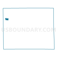
Outline

Summary
| Unique Area Identifier | 596105 |
| Name | Voting District 0257570000002 |
| County | Calhoun County |
| State | Michigan |
| Area (square miles) | 1.55 |
| Land Area (square miles) | 1.54 |
| Water Area (square miles) | 0.02 |
| % of Land Area | 98.85 |
| % of Water Area | 1.15 |
| Latitude of the Internal Point | 42.32989520 |
| Longtitude of the Internal Point | -85.25757340 |
Maps

Graphs
Select a template below for downloading or customizing gragh for Voting District 0257570000002, Calhoun County, Michigan


Neighbors
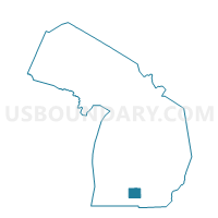
Neighoring Voting District (by Name) Neighboring Voting District on the Map
- Voting District 0250592000004, Calhoun County, MI
- Voting District 0250672000003B, Calhoun County, MI
- Voting District 0257570000001, Calhoun County, MI
Top 10 Neighboring County Subdivision (by Population) Neighboring County Subdivision on the Map
- Battle Creek city, Calhoun County, MI (52,347)
- Bedford charter township, Calhoun County, MI (9,357)
- Springfield city, Calhoun County, MI (5,260)
Top 10 Neighboring Place (by Population) Neighboring Place on the Map
Top 10 Neighboring Unified School District (by Population) Neighboring Unified School District on the Map
Top 10 Neighboring State Legislative District Lower Chamber (by Population) Neighboring State Legislative District Lower Chamber on the Map
Top 10 Neighboring State Legislative District Upper Chamber (by Population) Neighboring State Legislative District Upper Chamber on the Map
Top 10 Neighboring 111th Congressional District (by Population) Neighboring 111th Congressional District on the Map
Top 10 Neighboring Census Tract (by Population) Neighboring Census Tract on the Map
- Census Tract 14, Calhoun County, MI (4,199)
- Census Tract 13, Calhoun County, MI (4,092)
- Census Tract 26, Calhoun County, MI (1,885)